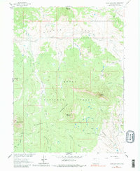
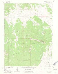
1962 Map of Bears Ears Peaks
USGS Topo · Published 1981About this map
Routt National Forest defines the character of this high-elevation landscape, where the Elkhead Mountains rise to distinctive points like Bears Ears Peaks and Columbus Mountain. The area is marked by a network of drainage systems feeding into Slater Creek and Elkhead Creek, creating deep basins such as Slater Park and Adams Park. This 1962 survey reveals a remote backcountry accessible primarily by Jeep Trails, supporting seasonal forestry and grazing activities rather than permanent settlements. The presence of the California Park Guard Station near California Creek suggests the administrative importance of the region for land management. Unique geographic features like Hole-in-the-Wall and Saddle Mountain punctuate the ridges, while various tributaries like Jakodowski Creek and Grizzly Creek carve through the timbered slopes.
Find a feature on this map
27 named features on this map. Tap any name to fly to it.
Don’t see what you’re looking for? This feature index may not catch every label — zoom into the map to look around manually.
Map Details
Editions of this 1962 Bears Ears Peaks Map
6 editions found

Other maps of this area

1923 · Elkhead Creek
USGS Topo · 1:62,500

1923 · Pilot Knob
USGS Topo · 1:62,500

1924 · Elkhead Creek
USGS Topo · 1:62,500

1925 · Pilot Knob
USGS Topo · 1:62,500

1954 · Craig
USGS Topo · 1:250,000

1957 · Craig
USGS Topo · 1:250,000

1958 · Craig
USGS Topo · 1:250,000

1960 · Craig
USGS Topo · 1:250,000

1962 · Craig
USGS Topo · 1:250,000
1962 · Tumble Mountain
USGS Topo · 1:24,000