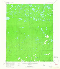
1956 Map of Beaver A-1
USGS Topo · Published 1963About this map
Beaver Creek meanders through this interior Alaska landscape, defining a complex network of sloughs and oxbow lakes typical of the Yukon River watershed in the mid-1950s. The survey illustrates a terrain dominated by low-lying wetlands and meadows, such as Big Meadow and Jefferson Meadows, which are interspersed among dense clusters of small lakes like Rat Lake and the New Halfway Lakes. Human presence is represented by a few isolated Cabin and Cabins structures, likely used for seasonal trapping or subsistence. A primary transportation artery is the Winter Trail in the northwest, which provided critical overland access during the frozen months when the marshy ground became passable. The map also records the presence of the Beaver Sl, emphasizing the hydrological shifts that characterize this remote subarctic region.
Find a feature on this map
20 named features on this map. Tap any name to fly to it.
Don’t see what you’re looking for? This feature index may not catch every label — zoom into the map to look around manually.
Map Details
Editions of this 1956 Beaver A-1 Map
2 editions found
Other maps of this area

1945 · Livengood
USGS Topo · 1:250,000

1951 · Fort Yukon
USGS Topo · 1:250,000

1951 · Livengood
USGS Topo · 1:250,000

1951 · Beaver
USGS Topo · 1:250,000

1951 · Circle
USGS Topo · 1:250,000

1951 · Circle D-6
USGS Topo · 1:63,360

1952 · Livengood D-2
USGS Topo · 1:63,360

1952 · Livengood D-1
USGS Topo · 1:63,360
1954 · Livengood D-2
USGS Topo · 1:63,360

1954 · Circle D-6
USGS Topo · 1:63,360