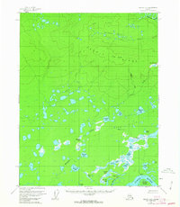
1956 Map of Beaver B-3
USGS Topo · Published 1987About this map
The Yukon River defines the southeastern corner of this sub-arctic landscape, where the abandoned site of Purgatory (Aband) sits along the river's edge near Marten Island. The terrain is a complex network of thousands of small water bodies and marshlands, notably the John Barleycorn Lakes, Queer Ponds, and Roaring Bear Lake. These are set against the backdrop of the Owl Hills and the prominent Hermit Ridge, which rises to a peak at Little Dome. The southern portion of the quadrangle is dominated by the Sand Hills, where drainage features like Meadow Creek and Bullrush Lake weave through the lowlands. To the north, the Hodzana River cuts across the corner of the map, illustrating the immense water-shed system that feeds into the Yukon valley in this era of mid-century Alaskan wilderness survey.
Find a feature on this map
38 named features on this map. Tap any name to fly to it.
Don’t see what you’re looking for? This feature index may not catch every label — zoom into the map to look around manually.
Map Details
Editions of this 1956 Beaver B-3 Map
3 editions found
Other maps of this area

1951 · Beaver
USGS Topo · 1:250,000

1956 · Beaver B-2
USGS Topo · 1:63,360

1956 · Beaver B-3
USGS Topo · 1:63,360

1956 · Beaver A-3
USGS Topo · 1:63,360
1956 · Beaver A-2
USGS Topo · 1:63,360

1956 · Beaver
USGS Topo · 1:250,000

1956 · Beaver A-4
USGS Topo · 1:63,360

1956 · Beaver B-4
USGS Topo · 1:63,360

1964 · Beaver
USGS Topo · 1:250,000
1970 · Beaver C-4
USGS Topo · 1:63,360