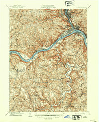
1904 Map of Beaver
USGS Topo · Published 1944About this map
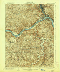
The Beaver River and Ohio River confluence serves as the industrial and logistical heart of this 1901 survey, where steep valley walls dictated a dense string of riverside settlements. Large industrial towns like Beaver Falls, New Brighton, and Rochester are connected by the Pittsburgh and Lake Erie Railroad, showing a landscape heavily shaped by early 20th-century transportation. Beyond the riverfront corridors of Monaca and Freedom, the topography rises sharply into the plateau, where smaller farming communities and family-named landmarks like McCleary and Green Garden are scattered among the winding drainages of Raccoon Creek and Service Creek. The presence of Dam No 5 and Dam No 6 along the Ohio highlights the critical role of river navigation for the region's economy. Smaller landings, such as Colonial Bakers Landing, suggest a period when river traffic was the primary link for local trade before the full expansion of the upland road network.
Find a feature on this map
83 named features on this map. Tap any name to fly to it.
Don’t see what you’re looking for? This feature index may not catch every label — zoom into the map to look around manually.
Map Details
Editions of this 1904 Beaver Map
6 editions found
Other maps of this area

1901 · Beaver
USGS Topo · 1:62,500

1902 · New Castle
USGS Topo · 1:62,500

1904 · Newcastle
USGS Topo · 1:62,500

1904 · Wellsville
USGS Topo · 1:62,500

1904 · Steubenville
USGS Topo · 1:62,500

1904 · Beaver
USGS Topo · 1:62,500

1904 · Carnegie
USGS Topo · 1:62,500

1904 · Burgettstown
USGS Topo · 1:62,500

1906 · Burgettstown
USGS Topo · 1:62,500

1906 · Carnegie
USGS Topo · 1:62,500