1885 Map of Beaver
USGS Topo · Published 1902About this map
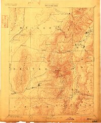
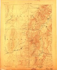
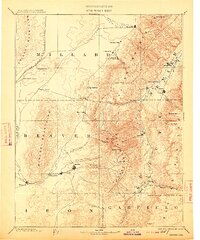
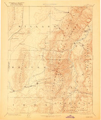
The Sevier River valley and its surrounding high-country peaks dominate this late nineteenth-century reconnaissance, capturing the early layout of central Utah settlements. The map details a corridor of agricultural and mining development, from Fillmore in the north down to Minersville. Higher-elevation terrain is defined by the massive Tushar Mountains, featuring Delano Peak and Baldy Peak, which overlook the valley floors. Transport patterns are clearly marked by the Utah Central Railroad cutting through the western flats near the Beaver Mountains. Genealogists will find interest in the distinct placement of small community centers like Adamsville, Greenville, and Joseph City, alongside natural landmarks such as Antelope Spring and the curiously named Gate of Monroe pass. The map effectively illustrates the reliance on mountain runoff, tracing Beaver Creek and Chalk Creek as they descend from the summits to support the pioneer settlements below.
Find a feature on this map
50 named features on this map. Tap any name to fly to it.
Don’t see what you’re looking for? This feature index may not catch every label — zoom into the map to look around manually.
Map Details
Editions of this 1885 Beaver Map
5 editions found
Other maps of this area

1885 · Manti
USGS Topo · 1:250,000

1885 · St. George
USGS Topo · 1:250,000

1885 · Beaver
USGS Topo · 1:250,000

1885 · Sevier Desert
USGS Topo · 1:250,000

1885 · Fish Lake
USGS Topo · 1:250,000

1886 · Kanab
USGS Topo · 1:250,000

1886 · Escalante
USGS Topo · 1:250,000

1891 · St. George
USGS Topo · 1:250,000

1895 · Manti
USGS Topo · 1:250,000

1896 · Fish Lake
USGS Topo · 1:250,000