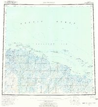
1955 Map of Beechey Point
USGS Topo · Published 1961About this map
Prudhoe Bay and the surrounding North Slope coastline appear here in their pre-development state during the mid-1950s. The map illustrates a complex network of braided rivers and coastal lagoons, dominated by the massive delta of the Sagavanirktok River and the Kuparuk River. At this time, human presence was limited to scattered Cabins, a lonely Lookout, and an Aerodrome near Oliktok Pt, reflecting an era of military and scientific exploration before the discovery of the Great Prudhoe Bay Oil Field.
Find a feature on this map
78 named features on this map. Tap any name to fly to it.
Don’t see what you’re looking for? This feature index may not catch every label — zoom into the map to look around manually.
Map Details
Editions of this 1955 Beechey Point Map
5 editions found
Other maps of this area

1951 · Harrison Bay
USGS Topo · 1:250,000

1951 · Beechey Point
USGS Topo · 1:250,000

1951 · Sagavanirktok D-5
USGS Topo · 1:250,000

1951 · Mt. Michelson
USGS Topo · 1:250,000

1952 · Umiat
USGS Topo · 1:250,000

1955 · Flaxman Island
USGS Topo · 1:250,000

1955 · Harrison Bay
USGS Topo · 1:250,000

1955 · Beechey Point
USGS Topo · 1:250,000

1955 · Mount Michelson D-5
USGS Topo · 1:63,360

1955 · Harrison Bay C-1
USGS Topo · 1:63,360