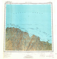
1955 Map of Beechey Point
USGS Topo · Published 1965About this map
Prudhoe Bay and the northernmost reaches of the Alaska coast appear here as they were in the mid-1950s, more than a decade before the discovery of the North Slope oil fields transformed the region's global profile. The landscape is dominated by the braided outlets of the Kuparuk River, Sagavanirktok River, and Kadleroshilik River, which spill into the Beaufort Sea across a vast, lake-pocked coastal plain. Scattered cabins and a lone Aerodrome mark the minimal human footprint of the era, while the coastline is defined by barrier island chains like the Spy Islands and the Return Islands. This survey illustrates the intricate hydrography of the region, where the Arctic Ocean meets an expansive network of lagoons and bays, including Simpson Lagoon and Gwydyr Bay, before large-scale industrial infrastructure reached these shores.
Find a feature on this map
89 named features on this map. Tap any name to fly to it.
Don’t see what you’re looking for? This feature index may not catch every label — zoom into the map to look around manually.
Map Details
Editions of this 1955 Beechey Point Map
5 editions found
Other maps of this area

1951 · Harrison Bay
USGS Topo · 1:250,000

1951 · Beechey Point
USGS Topo · 1:250,000

1951 · Sagavanirktok D-5
USGS Topo · 1:250,000

1951 · Mt. Michelson
USGS Topo · 1:250,000

1952 · Umiat
USGS Topo · 1:250,000

1955 · Flaxman Island
USGS Topo · 1:250,000

1955 · Harrison Bay
USGS Topo · 1:250,000

1955 · Beechey Point
USGS Topo · 1:250,000

1955 · Mount Michelson D-5
USGS Topo · 1:63,360

1955 · Harrison Bay C-1
USGS Topo · 1:63,360