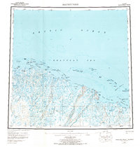
1955 Map of Beechey Point
USGS Topo · Published 1968About this map
The Arctic Ocean shoreline of Alaska's North Slope is captured here during the mid-1950s, a period before the discovery of the Prudhoe Bay Oil Field transformed the region's infrastructure. The landscape is defined by an intricate network of waterways, including the braided channels of the Sagavanirktok River and the Kuparuk River, which empty into a series of shallow coastal features like Simpson Lagoon and Gwydyr Bay. At this time, human presence was sparse, marked only by isolated Cabins and a Cabin on Tigvariak Island.
Find a feature on this map
51 named features on this map. Tap any name to fly to it.
Don’t see what you’re looking for? This feature index may not catch every label — zoom into the map to look around manually.
Map Details
Editions of this 1955 Beechey Point Map
5 editions found
Other maps of this area

1951 · Harrison Bay
USGS Topo · 1:250,000

1951 · Beechey Point
USGS Topo · 1:250,000

1951 · Sagavanirktok D-5
USGS Topo · 1:250,000

1951 · Mt. Michelson
USGS Topo · 1:250,000

1952 · Umiat
USGS Topo · 1:250,000

1955 · Flaxman Island
USGS Topo · 1:250,000

1955 · Harrison Bay
USGS Topo · 1:250,000

1955 · Beechey Point
USGS Topo · 1:250,000

1955 · Mount Michelson D-5
USGS Topo · 1:63,360

1955 · Harrison Bay C-1
USGS Topo · 1:63,360