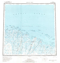
1955 Map of Beechey Point
USGS Topo · Published 1970About this map
Prudhoe Bay and the surrounding Arctic coastline are captured here in the mid-1950s, a period prior to the massive infrastructure expansion of the Alaskan oil era. The landscape is defined by the complex hydrology of the North Slope, where the Sagavanirktok River, Kuparuk River, and Shaviovik River flow north through a network of lakes and tundra toward the Beaufort Sea. Evidence of early human presence and navigation is visible in several isolated cabins and the Winter Trail that cuts across the frozen terrain. Critical early aviation markers like the Aerodrome near Oliktok Pt and the Landing Area at Deadhorse suggest the area's emerging strategic and logistical importance. The map details numerous offshore features such as the Jones Islands and the Midway Islands, which provided shelter for coastal travel along this remote stretch of the Arctic Ocean.
Find a feature on this map
65 named features on this map. Tap any name to fly to it.
Don’t see what you’re looking for? This feature index may not catch every label — zoom into the map to look around manually.
Map Details
Editions of this 1955 Beechey Point Map
5 editions found
Other maps of this area

1951 · Harrison Bay
USGS Topo · 1:250,000

1951 · Beechey Point
USGS Topo · 1:250,000

1951 · Sagavanirktok D-5
USGS Topo · 1:250,000

1951 · Mt. Michelson
USGS Topo · 1:250,000

1952 · Umiat
USGS Topo · 1:250,000

1955 · Flaxman Island
USGS Topo · 1:250,000

1955 · Harrison Bay
USGS Topo · 1:250,000

1955 · Beechey Point
USGS Topo · 1:250,000

1955 · Mount Michelson D-5
USGS Topo · 1:63,360

1955 · Harrison Bay C-1
USGS Topo · 1:63,360