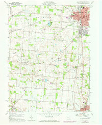
1960 Map of Bellefontaine
USGS Topo · Published 1973About this map
The county seat of Bellefontaine serves as the focal point of this Logan County landscape, where the Penn Central rail lines converge near the Courthouse and Library. The urban core is surrounded by an intricate network of rural settlements and small-scale agriculture, marked by several historic family and community burial grounds such as Parish Cem, Miller Cem, and Tanger Cem. To the south, the village of West Liberty sits near the banks of the Mad River, while Springhills and Wortman dot the western reaches.
Find a feature on this map
61 named features on this map. Tap any name to fly to it.
Don’t see what you’re looking for? This feature index may not catch every label — zoom into the map to look around manually.
Map Details
Editions of this 1960 Bellefontaine Map
4 editions found
Other maps of this area

1913 · Bellefontaine
USGS Topo · 1:48,000

1913 · East Liberty
USGS Topo · 1:62,500

1914 · St. Paris
USGS Topo · 1:62,500

1914 · Mechanicsburg
USGS Topo · 1:62,500

1915 · Bellefontaine
USGS Topo · 1:62,500

1915 · East Liberty
USGS Topo · 1:62,500

1916 · Mechanicsburg
USGS Topo · 1:62,500

1916 · St. Paris
USGS Topo · 1:62,500

1944 · East Liberty
USGS Topo · 1:62,500

1944 · Mechanicsburg
USGS Topo · 1:62,500