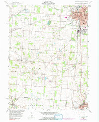
1960 Map of Bellefontaine
USGS Topo · Published 1992About this map
Bellefontaine serves as the regional anchor of this landscape, where the Penn Central rail lines converge near the Courthouse and City Hall. The surrounding Logan County countryside is defined by glacial features, most notably the numerous small water bodies like Doke Lake, Ruby Lake, and McMillen Lake that dot the terrain between Harrison and Union townships. A distinct geological marker, a Sink Hole, is recorded south of the Bellefontaine Pike, illustrating the area's limestone-influenced topography.
Find a feature on this map
64 named features on this map. Tap any name to fly to it.
Don’t see what you’re looking for? This feature index may not catch every label — zoom into the map to look around manually.
Map Details
Editions of this 1960 Bellefontaine Map
4 editions found
Other maps of this area

1913 · Bellefontaine
USGS Topo · 1:48,000

1913 · East Liberty
USGS Topo · 1:62,500

1914 · St. Paris
USGS Topo · 1:62,500

1914 · Mechanicsburg
USGS Topo · 1:62,500

1915 · Bellefontaine
USGS Topo · 1:62,500

1915 · East Liberty
USGS Topo · 1:62,500

1916 · Mechanicsburg
USGS Topo · 1:62,500

1916 · St. Paris
USGS Topo · 1:62,500

1944 · East Liberty
USGS Topo · 1:62,500

1944 · Mechanicsburg
USGS Topo · 1:62,500