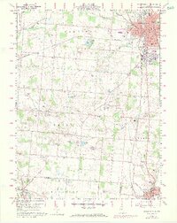
1960 Map of Bellefontaine
USGS Topo · Published 1973About this map
Bellefontaine serves as the focal point of this Logan County landscape, where the Penn Central rail lines converge at the city center near the Courthouse and Rutan Hospital. The surrounding rural townships of Harrison, Union, and Liberty reveal a post-war agricultural pattern dotted with small family-named landmarks and local institutions. Significant for genealogists are the numerous rural burial grounds such as Tanger Cem, Sagers Cem, and Alexander Cem, which anchor the histories of the surrounding farmsteads. The terrain is defined by a series of small glacial lakes and ponds, including Silver Lake and McMillen Lake, alongside distinctive geological features like a prominent Sink Hole in the south. Aviation history is noted by the presence of Tangers Airport and its associated storage bins, reflecting the era's light infrastructure.
Find a feature on this map
67 named features on this map. Tap any name to fly to it.
Don’t see what you’re looking for? This feature index may not catch every label — zoom into the map to look around manually.
Map Details
Editions of this 1960 Bellefontaine Map
4 editions found
Other maps of this area

1913 · Bellefontaine
USGS Topo · 1:48,000

1913 · East Liberty
USGS Topo · 1:62,500

1914 · St. Paris
USGS Topo · 1:62,500

1914 · Mechanicsburg
USGS Topo · 1:62,500

1915 · Bellefontaine
USGS Topo · 1:62,500

1915 · East Liberty
USGS Topo · 1:62,500

1916 · Mechanicsburg
USGS Topo · 1:62,500

1916 · St. Paris
USGS Topo · 1:62,500

1944 · East Liberty
USGS Topo · 1:62,500

1944 · Mechanicsburg
USGS Topo · 1:62,500