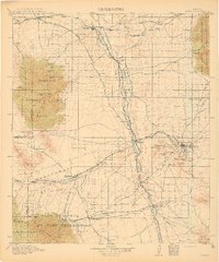
1915 Map of Benson
USGS Topo · Published 1915About this map
Benson and Tombstone serve as the primary anchors of this Southern Arizona landscape, which in the early twentieth century was defined by a complex intersection of mining, military presence, and rail logistics. The San Pedro River valley acts as the central corridor for both water and transport, supporting settlements like St David and Fairbank. The mining legacy of the era is evident in the hills surrounding Tombstone, where features like the Panama Mine and numerous gulches point to the intensive extraction efforts of the day. To the southwest, the Fort Huachuca Military Reservation dominates the base of the Huachuca Mts, reflecting the strategic importance of this borderland region. Transport is facilitated by an extensive network of the Southern Pacific and El Paso and Southwestern railroads, which connect ranching outposts such as Boedeckers Ranch and Wakefield Ranch to the larger regional hubs.
Find a feature on this map
96 named features on this map. Tap any name to fly to it.
Don’t see what you’re looking for? This feature index may not catch every label — zoom into the map to look around manually.
Map Details
Editions of this 1915 Benson Map
4 editions found
Other maps of this area

1902 · Bisbee
USGS Topo · 1:62,500

1904 · Patagonia
USGS Topo · 1:125,000

1904 · Tucson
USGS Topo · 1:125,000

1905 · Patagonia
USGS Topo · 1:125,000

1905 · Tucson
USGS Topo · 1:125,000

1905 · Nogales
USGS Topo · 1:125,000

1910 · Bisbee
USGS Topo · 1:62,500

1914 · Hereford
USGS Topo · 1:125,000

1915 · Benson
USGS Topo · 1:125,000

1916 · Pearce
USGS Topo · 1:125,000