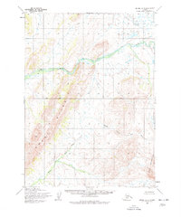
1954 Map of Bethel A-5
USGS Topo · Published 1978About this map
Great Ridge dominates the western landscape of this mid-century survey, forming a prominent topographical spine across the Seward Meridian. This territory, mapped by the Army Map Service and the Geological Survey, captures a wild interior drainage system defined by the Eek River and its major tributary, the Middle Fork Eek River. The terrain transitions from these watercourses toward the Eek Mountains in the southeast corner. A notable surveying marker, the east-west Base Line, bisects the quadrangle, providing a rare human-imposed geometry upon the complex network of unnamed ridges and glacial valleys. The map represents a period of systematic aerial photogrammetric mapping in the 1950s, documenting a landscape devoid of roads or permanent settlements in this specific corridor.
Find a feature on this map
5 named features on this map. Tap any name to fly to it.
Don’t see what you’re looking for? This feature index may not catch every label — zoom into the map to look around manually.
Map Details
Editions of this 1954 Bethel A-5 Map
2 editions found
Other maps of this area

1950 · Bethel
USGS Topo · 1:250,000

1951 · Goodnews
USGS Topo · 1:250,000

1954 · Bethel B-6
USGS Topo · 1:63,360

1954 · Bethel A-5
USGS Topo · 1:63,360

1954 · Bethel A-4
USGS Topo · 1:63,360

1954 · Bethel B-4
USGS Topo · 1:63,360

1954 · Goodnews D-4
USGS Topo · 1:63,360

1954 · Bethel B-5
USGS Topo · 1:63,360

1954 · Goodnews D-6
USGS Topo · 1:63,360

1954 · Goodnews D-5
USGS Topo · 1:63,360