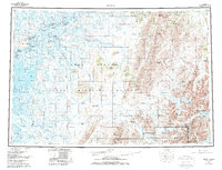
1980 Map of Bethel
USGS Topo · Published 1987About this map
Bethel serves as the focal point for this survey, situated at a bend in the Kuskokwim River. The surrounding delta is defined by a dense network of sloughs and tributaries, including the Kuskokwak Slough and Kisaralik River, which connect native settlements like Akiachak, Akiak, and Kwethluk. Outside the river corridors, the landscape transitions into the heights of the Kilbuck Mountains and the Sawtooth Mountains, where landmarks such as Shining Dome and Marvel Dome stand out. Extensive protected lands are detailed, with the Yukon Delta National Wildlife Refuge and Togiak National Wildlife Refuge covering much of the terrain. A noted Winter Trail cuts across the tundra, reflecting the seasonal transport patterns essential to life in the Kuskokwak region before modern infrastructure was established.
Find a feature on this map
76 named features on this map. Tap any name to fly to it.
Don’t see what you’re looking for? This feature index may not catch every label — zoom into the map to look around manually.
Map Details
Editions of this 1980 Bethel Map
4 editions found

Other maps of this area

1947 · Russian Mission
USGS Topo · 1:250,000

1950 · Russian Mission
USGS Topo · 1:250,000

1950 · Sleetmute
USGS Topo · 1:250,000

1950 · Bethel
USGS Topo · 1:250,000

1950 · Taylor Mountains
USGS Topo · 1:250,000

1951 · Marshall
USGS Topo · 1:250,000

1951 · Taylor Mountains
USGS Topo · 1:250,000

1951 · Kuskokwim Bay
USGS Topo · 1:250,000

1951 · Dillingham
USGS Topo · 1:250,000

1951 · Goodnews
USGS Topo · 1:250,000