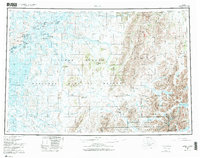
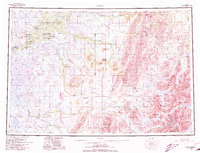
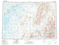
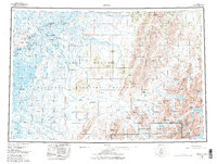
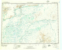
1980 Map of Bethel
USGS Topo · Published 1987About this map
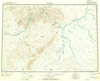
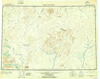
The Kuskokwim River serves as the central artery for this 1980s landscape, connecting a network of riverside settlements including Bethel, Akiachak, and Kwethluk. The map illustrates a region defined by its reliance on the water and seasonal movement, marked by the presence of a Winter Trail and the regional Airport at Bethel. Large protected areas dominate the surrounding terrain, with the Yukon Delta National Wildlife Refuge and the Togiak National Wildlife Refuge covering vast stretches of tundra and mountains. To the east, the topography shifts dramatically as the land rises into the Kilbuck Mountains, where prominent peaks like Marvel Dome and Mount Romig overlook the headwaters of the Kisaralik River and Eek River. Notable local landmarks such as Graveyard Point near Oscarville and the landing strip at Napakiak highlight the specific sites of community life and transport in the Kuskokwim Delta.
Find a feature on this map
52 named features on this map. Tap any name to fly to it.
Don’t see what you’re looking for? This feature index may not catch every label — zoom into the map to look around manually.
Map Details
Editions of this 1980 Bethel Map
4 editions found
Other maps of this area
1947 · Russian Mission
USGS Topo · 1:250,000

1950 · Russian Mission
USGS Topo · 1:250,000
1950 · Sleetmute
USGS Topo · 1:250,000

1950 · Bethel
USGS Topo · 1:250,000

1950 · Taylor Mountains
USGS Topo · 1:250,000

1951 · Marshall
USGS Topo · 1:250,000
1951 · Taylor Mountains
USGS Topo · 1:250,000

1951 · Kuskokwim Bay
USGS Topo · 1:250,000

1951 · Dillingham
USGS Topo · 1:250,000

1951 · Goodnews
USGS Topo · 1:250,000