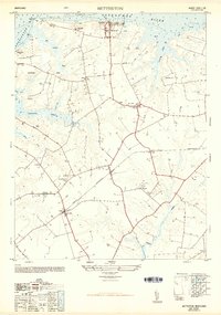
1948 Map of Betterton
USGS Topo · Published 1949About this map
Betterton sits at the northern edge of this Kent County landscape, overlooking the Sassafras River as it meets the Chesapeake Bay. In the late 1940s, the area remained deeply agricultural, characterized by named holdings like Five Rivers Farm and specialized operations such as the Blooming Turkey Farm. The interior geography is defined by extensive wetlands, including Big Marsh and Gut Marsh, which underscore the region's coastal ecology. A Wild life Banding Station along Lloyd Creek points to the environmental significance of these marshes.
Find a feature on this map
47 named features on this map. Tap any name to fly to it.
Don’t see what you’re looking for? This feature index may not catch every label — zoom into the map to look around manually.
Map Details
Editions of this 1948 Betterton Map
4 editions found
Other maps of this area

1898 · Tolchester
USGS Topo · 1:125,000

1899 · Dover
USGS Topo · 1:125,000

1900 · Cecilton
USGS Topo · 1:62,500

1900 · Betterton
USGS Topo · 1:62,500

1901 · Chestertown
USGS Topo · 1:62,500

1903 · Tolchester
USGS Topo · 1:125,000

1905 · Barclay
USGS Topo · 1:62,500

1906 · Dover
USGS Topo · 1:125,000

1908 · Tolchester
USGS Topo · 1:125,000

1920 · Dover
USGS Topo · 1:125,000