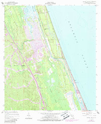
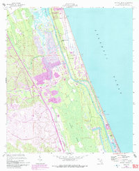
1956 Map of Beverly Beach
USGS Topo · Published 1988About this map
Matanzas River and the Intracoastal Waterway carve a distinct north-south corridor through this coastal Florida landscape, separating the barrier island developments from the dense wetlands of Graham Swamp. The 1988 photorevisions highlight a period of significant growth along the shoreline, particularly in the namesake settlement of Beverly Beach and nearby Painters Hill. Residential street grids and a Golf Course expand across the terrain between Long Creek and the coast, while older landmarks like the Johnson Memorial Chapel and the Lookout Tower near Bon Terra remain as established navigational points.
Find a feature on this map
18 named features on this map. Tap any name to fly to it.
Don’t see what you’re looking for? This feature index may not catch every label — zoom into the map to look around manually.
Map Details
Editions of this 1956 Beverly Beach Map
5 editions found
Other maps of this area

1927 · Matanzas
USGS Topo · 1:48,000

1937 · Dinner Island
USGS Topo · 1:48,000

1937 · Ormond
USGS Topo · 1:48,000

1943 · Dinner Island
USGS Topo · 1:62,500

1943 · Matanzas
USGS Topo · 1:62,500

1944 · Ormond
USGS Topo · 1:62,500

1944 · Dinner Island
USGS Topo · 1:62,500

1944 · Matanzas
USGS Topo · 1:62,500

1954 · Daytona Beach
USGS Topo · 1:250,000

1956 · Dinner Island NE
USGS Topo · 1:24,000