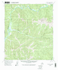
1958 Map of Big Delta B-2
USGS Topo · Published 1976About this map
Goodpaster River meanders through the northern interior of this Alaskan landscape, defining the low-lying wetlands that contrast with the surrounding high country. The terrain is marked by several significant summits, most notably Shawnee Peak, which stands as a central landmark amidst a complex network of drainages. This mid-century survey reveals a wilderness accessed primarily by water and a single Tractor Trail that cuts across the central valleys. Isolated Cabins along the riverbanks suggest the seasonal presence of trappers, prospectors, or surveyors in an era when much of the interior remained remote and largely untouched by permanent development. The drainage patterns of Central Creek, Big Swede Creek, and White Creek illustrate the intricate watershed that feeds the larger Goodpaster system.
Find a feature on this map
13 named features on this map. Tap any name to fly to it.
Don’t see what you’re looking for? This feature index may not catch every label — zoom into the map to look around manually.
Map Details
Editions of this 1958 Big Delta B-2 Map
3 editions found
Other maps of this area

1950 · Big Delta
USGS Topo · 1:250,000

1951 · Big Delta
USGS Topo · 1:250,000

1954 · Big Delta A-2
USGS Topo · 1:63,360

1955 · Big Delta A-3
USGS Topo · 1:63,360

1955 · Big Delta A-1
USGS Topo · 1:63,360

1955 · Big Delta A-2
USGS Topo · 1:63,360

1958 · Big Delta B-3
USGS Topo · 1:63,360

1958 · Big Delta C-3
USGS Topo · 1:63,360

1958 · Big Delta B-2
USGS Topo · 1:63,360

1958 · Big Delta B-1
USGS Topo · 1:63,360