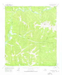
1958 Map of Big Delta B-2
USGS Topo · Published 1976About this map
The Goodpaster River meanders through this interior Alaska landscape, defining a remote corridor of wilderness and early transportation during the mid-20th century. Scattered Cabins and a network of Tractor Trails suggest the persistent use of the land for trapping, prospecting, or subsistence, even as the region remained largely undeveloped. The topography is dominated by the prominence of Shawnee Peak, which towers over the drainages of Central Creek, Sonora Creek, and California Creek.
Find a feature on this map
13 named features on this map. Tap any name to fly to it.
Don’t see what you’re looking for? This feature index may not catch every label — zoom into the map to look around manually.
Map Details
Editions of this 1958 Big Delta B-2 Map
3 editions found
Other maps of this area

1950 · Big Delta
USGS Topo · 1:250,000

1951 · Big Delta
USGS Topo · 1:250,000

1954 · Big Delta A-2
USGS Topo · 1:63,360

1955 · Big Delta A-3
USGS Topo · 1:63,360

1955 · Big Delta A-1
USGS Topo · 1:63,360

1955 · Big Delta A-2
USGS Topo · 1:63,360

1958 · Big Delta B-3
USGS Topo · 1:63,360

1958 · Big Delta C-3
USGS Topo · 1:63,360

1958 · Big Delta B-2
USGS Topo · 1:63,360

1958 · Big Delta B-1
USGS Topo · 1:63,360