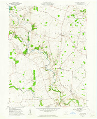
1961 Map of Big Plain
USGS Topo · Published 1962About this map
Deer Creek meanders through the heart of this agricultural landscape in Madison County, anchoring a region defined by its complex network of drainage ditches and small crossroads communities. Near the center of the sheet, an ancient Indian Mound stands as a quiet reminder of early inhabitants, situated not far from Kiousville and the winding waters of the creek. This area, entirely within the Virginia Military District, displays a surveyor's grid often interrupted by the natural paths of Oak Run and Glade Run.
Find a feature on this map
55 named features on this map. Tap any name to fly to it.
Don’t see what you’re looking for? This feature index may not catch every label — zoom into the map to look around manually.
Map Details
Editions of this 1961 Big Plain Map
2 editions found
Other maps of this area

1906 · Mt Sterling
USGS Topo · 1:62,500

1907 · London
USGS Topo · 1:62,500

1911 · Era
USGS Topo · 1:62,500

1913 · Era
USGS Topo · 1:62,500

1923 · West Columbus
USGS Topo · 1:62,500

1925 · West Columbus
USGS Topo · 1:62,500

1943 · Era
USGS Topo · 1:62,500

1947 · Columbus
USGS Topo · 1:250,000

1955 · Harrisburg
USGS Topo · 1:24,000
1955 · Galloway
USGS Topo · 1:24,000