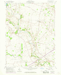
1961 Map of Big Plain
USGS Topo · Published 1968About this map
Deer Creek meanders through the heart of the Virginia Military District in Madison County, defining a landscape of agricultural tracts and scattered rural settlements during the early 1960s. The village of Big Plain serves as a central point for the surrounding farmsteads, connected by a network of local roads such as Big Plain Circleville Road and Kiousville Road. This edition includes purple photorevised updates from 1968, showing residential development and field line changes near Madison Lake State Park in the northwest. Local history is deeply etched into the terrain, evidenced by the Indian Mound near Timmons Cem and the presence of several country burial grounds like Graham Cem and Dennison Cem. The drainage of the till plains is meticulously documented through numerous named ditches, including McGuire Ditch and Antioch Ditch, which support the intensive farming of the Fairfield and Pleasant townships.
Find a feature on this map
54 named features on this map. Tap any name to fly to it.
Don’t see what you’re looking for? This feature index may not catch every label — zoom into the map to look around manually.
Map Details
Editions of this 1961 Big Plain Map
2 editions found
Other maps of this area

1906 · Mt Sterling
USGS Topo · 1:62,500

1907 · London
USGS Topo · 1:62,500

1911 · Era
USGS Topo · 1:62,500

1913 · Era
USGS Topo · 1:62,500

1923 · West Columbus
USGS Topo · 1:62,500

1925 · West Columbus
USGS Topo · 1:62,500

1943 · Era
USGS Topo · 1:62,500

1947 · Columbus
USGS Topo · 1:250,000

1955 · Harrisburg
USGS Topo · 1:24,000
1955 · Galloway
USGS Topo · 1:24,000