
1962 Map of Bismarck
USGS Topo · Published 1964About this map
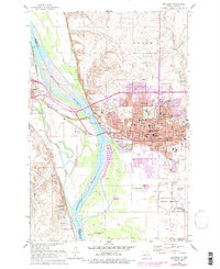
The Missouri River corridor serves as the central artery for this mid-century view of North Dakota's capital, where the Northern Pacific railroad and the Soo Line converge. The cityscape is dominated by the high-rise Capitol building and the campus of Bismarck Jr College, while the western bank features the neighboring community of Mandan. South of the urban center, the landscape is deeply rooted in frontier history, containing the Fort Lincoln Historic Site Ruins and the Fort McKeen Historic Site. The juxtaposition of the Fort Lincoln Military Reservation and the State Prison Farm against the emerging residential neighborhoods like Highland Acres illustrates the region's mid-century transition from a frontier outpost and agricultural hub into a modernized political and transportation center.
Find a feature on this map
66 named features on this map. Tap any name to fly to it.
Don’t see what you’re looking for? This feature index may not catch every label — zoom into the map to look around manually.
Map Details
Editions of this 1962 Bismarck Map
3 editions found
Other maps of this area

1907 · Bismarck
USGS Topo · 1:125,000

1950 · Bismarck
USGS Topo · 1:24,000

1951 · Menoken SW
USGS Topo · 1:24,000

1951 · Bismarck
USGS Topo · 1:62,500

1951 · Mandan
USGS Topo · 1:24,000

1951 · Menoken
USGS Topo · 1:62,500

1954 · Bismarck
USGS Topo · 1:250,000

1958 · Bismarck
USGS Topo · 1:250,000

1962 · Sugarloaf Butte
USGS Topo · 1:24,000

1962 · Schmidt
USGS Topo · 1:24,000