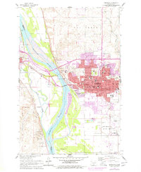
1962 Map of Bismarck
USGS Topo · Published 1977About this map
The Missouri River and Heart River define the development of this state capital during the mid-twentieth century. Revisions from 1976 highlight the rapid expansion of Bismarck, specifically northward into Highland Acres and eastward through new residential developments and schools like Northridge Sch. The landscape retains deep ties to the frontier era, preserved at the Fort Lincoln State Park and the Fort McKeen Historic Site situated along the western bluffs.
Find a feature on this map
64 named features on this map. Tap any name to fly to it.
Don’t see what you’re looking for? This feature index may not catch every label — zoom into the map to look around manually.
Map Details
Editions of this 1962 Bismarck Map
3 editions found

Other maps of this area

1907 · Bismarck
USGS Topo · 1:125,000

1950 · Bismarck
USGS Topo · 1:24,000

1951 · Menoken SW
USGS Topo · 1:24,000

1951 · Bismarck
USGS Topo · 1:62,500

1951 · Mandan
USGS Topo · 1:24,000

1951 · Menoken
USGS Topo · 1:62,500

1954 · Bismarck
USGS Topo · 1:250,000

1958 · Bismarck
USGS Topo · 1:250,000

1962 · Sugarloaf Butte
USGS Topo · 1:24,000

1962 · Schmidt
USGS Topo · 1:24,000