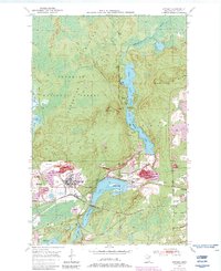
1950 Map of Biwabik
USGS Topo · Published 1983About this map
The Laurentian Divide cuts across this section of the Mesabi Iron Range, where the industrial footprint of mid-century mining dominates the landscape. The city of Biwabik sits at the heart of this activity, surrounded by massive operations such as the Biwabik Mine, Canton Mine, and Ajax Mine. The complex topography is defined by numerous mine dumps and open pits, including the Hudson Pit and Inactive Mine sites near Aurora.
Find a feature on this map
35 named features on this map. Tap any name to fly to it.
Don’t see what you’re looking for? This feature index may not catch every label — zoom into the map to look around manually.
Map Details
Editions of this 1950 Biwabik Map
5 editions found
Other maps of this area

1949 · Aurora
USGS Topo · 1:24,000

1949 · Embarrass
USGS Topo · 1:24,000

1950 · Embarrass
USGS Topo · 1:24,000

1950 · Aurora
USGS Topo · 1:24,000

1950 · Biwabik
USGS Topo · 1:24,000

1950 · Mc Kinley
USGS Topo · 1:24,000

1950 · Biwabik NW
USGS Topo · 1:24,000

1950 · Biwabik NE
USGS Topo · 1:24,000

1951 · Biwabik
USGS Topo · 1:24,000

1951 · Mc Kinley
USGS Topo · 1:24,000