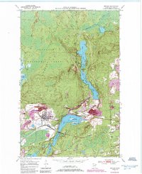
1950 Map of Biwabik
USGS Topo · Published 1985About this map
Industrial activity on the Iron Range is the centerpiece of this mid-century topographic record, where the landscape is fundamentally shaped by open-pit excavation and massive tailings piles. The Embarrass Mine and Canton Mine dominate the southern portion of the sheet, revealing the extensive infrastructure required to support the region's mineral output. Between these industrial sites, the residential cores of Biwabik, Pineville, and Belgrade provide housing for the local workforce, connected by the rails of the Duluth Missabe and Iron Range.
Find a feature on this map
33 named features on this map. Tap any name to fly to it.
Don’t see what you’re looking for? This feature index may not catch every label — zoom into the map to look around manually.
Map Details
Editions of this 1950 Biwabik Map
5 editions found
Other maps of this area

1949 · Aurora
USGS Topo · 1:24,000

1949 · Embarrass
USGS Topo · 1:24,000

1950 · Embarrass
USGS Topo · 1:24,000

1950 · Aurora
USGS Topo · 1:24,000

1950 · Biwabik
USGS Topo · 1:24,000

1950 · Mc Kinley
USGS Topo · 1:24,000

1950 · Biwabik NW
USGS Topo · 1:24,000

1950 · Biwabik NE
USGS Topo · 1:24,000

1951 · Biwabik
USGS Topo · 1:24,000

1951 · Mc Kinley
USGS Topo · 1:24,000