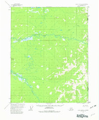
1956 Map of Black River A-1
USGS Topo · Published 1982About this map
The Alaska Yukon boundary defines the eastern edge of this 1950s interior landscape, where the United States Canada border meets the high country of the eastern interior. The Grayling Fork Black River dominates the central portion of the map, carving a wide path through a terrain defined by significant elevation markers and isolated peaks. This region is characterized by its drainage networks, including Tikan Creek and the meandering Bull Creek to the south.
Find a feature on this map
10 named features on this map. Tap any name to fly to it.
Don’t see what you’re looking for? This feature index may not catch every label — zoom into the map to look around manually.
Map Details
Editions of this 1956 Black River A-1 Map
3 editions found
Other maps of this area

1951 · Charley River
USGS Topo · 1:250,000

1951 · Black River
USGS Topo · 1:250,000
1956 · Black River A-1
USGS Topo · 1:63,360

1956 · Black River A-2
USGS Topo · 1:63,360

1956 · Black River B-2
USGS Topo · 1:63,360

1956 · Black River B-1
USGS Topo · 1:63,360

1956 · Black River
USGS Topo · 1:250,000

1956 · Charley River D-2
USGS Topo · 1:63,360
1956 · Charley River D-1
USGS Topo · 1:63,360

1956 · Charley River
USGS Topo · 1:250,000