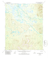
1956 Map of Black River A-2
USGS Topo · Published 1987About this map
The Grayling Fork Black River meanders across a landscape defined by expansive wetlands and intricate hydrology in the mid-1950s. This survey, based on aerial photography from 1954 and 1955, illustrates a territory where the drainage patterns of Bull Creek and Dempsey Creek dominate the interior. The land lines shown represent unsurveyed and unmarked locations predetermined by the Bureau of Land Management, reflecting the remote nature of this portion of the Fairbanks Meridian at the time of field annotation.
Find a feature on this map
7 named features on this map. Tap any name to fly to it.
Don’t see what you’re looking for? This feature index may not catch every label — zoom into the map to look around manually.
Map Details
Editions of this 1956 Black River A-2 Map
3 editions found
Other maps of this area

1951 · Charley River
USGS Topo · 1:250,000

1951 · Black River
USGS Topo · 1:250,000
1956 · Black River A-1
USGS Topo · 1:63,360

1956 · Black River A-2
USGS Topo · 1:63,360

1956 · Black River B-3
USGS Topo · 1:63,360

1956 · Black River B-2
USGS Topo · 1:63,360

1956 · Black River B-1
USGS Topo · 1:63,360

1956 · Black River A-3
USGS Topo · 1:63,360

1956 · Charley River D-3
USGS Topo · 1:63,360

1956 · Black River
USGS Topo · 1:250,000