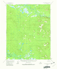
1956 Map of Black River B-2
USGS Topo · Published 1982About this map
The Salmon Fork Black River and the Grayling Fork Black River define this subarctic interior Alaskan landscape, meandering through complex networks of wetlands and oxbow lakes. These two major forks of the Black River system dominate the northern and southern quadrants of the map, respectively, illustrating a wilderness environment where water and muskeg are the primary geographical features. Rising above the low-lying river valleys, Big Mountain and the distinctively named Pink Bluff provide the few significant elevations in an otherwise saturated terrain. The absence of roads or established trails, as noted by the U.S. Geological Survey, underscores the isolation of the area in the mid-1950s. Only small tributaries like Runt Cr break the vast expanse of unnamed lakes and marshes, showing a landscape shaped almost entirely by natural hydrological cycles rather than human settlement.
Find a feature on this map
5 named features on this map. Tap any name to fly to it.
Don’t see what you’re looking for? This feature index may not catch every label — zoom into the map to look around manually.
Map Details
Editions of this 1956 Black River B-2 Map
3 editions found
Other maps of this area

1951 · Black River
USGS Topo · 1:250,000
1956 · Black River A-1
USGS Topo · 1:63,360

1956 · Black River A-2
USGS Topo · 1:63,360

1956 · Black River B-3
USGS Topo · 1:63,360

1956 · Black River B-2
USGS Topo · 1:63,360

1956 · Black River B-1
USGS Topo · 1:63,360

1956 · Black River A-3
USGS Topo · 1:63,360

1956 · Black River C-2
USGS Topo · 1:63,360
1956 · Black River C-1
USGS Topo · 1:63,360

1956 · Black River C-3
USGS Topo · 1:63,360