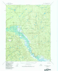
1956 Map of Black River B-5
USGS Topo · Published 1984About this map
The Black River meanders through a landscape of wetlands and low-lying terrain in this interior Alaska region. Much of the area is defined by the Yukon Flats, a broad floodplain characterized by a complex network of small lakes and marshes. Tchulkade Lake stands as one of the larger named water bodies within this intricate aquatic system, situated west of the main river channel. The topography is generally subtle, though Bearnose Hill provides a distinct rise in elevation to the northwest. Following the Alaska National Interest Lands Conservation Act in 1980, these lands were formally incorporated into the Yukon Flats National Wildlife Refuge. The map details the transition from the wet basin to the higher ground marked by the Refuge Boundary in the south, illustrating the vast, roadless environment of the subarctic wilderness as it was documented in the mid-1950s.
Find a feature on this map
6 named features on this map. Tap any name to fly to it.
Don’t see what you’re looking for? This feature index may not catch every label — zoom into the map to look around manually.
Map Details
Editions of this 1956 Black River B-5 Map
2 editions found
Other maps of this area

1951 · Black River
USGS Topo · 1:250,000

1956 · Black River B-6
USGS Topo · 1:63,360

1956 · Black River A-4
USGS Topo · 1:63,360

1956 · Black River B-5
USGS Topo · 1:63,360

1956 · Black River C-6
USGS Topo · 1:63,360

1956 · Black River B-4
USGS Topo · 1:63,360

1956 · Black River C-5
USGS Topo · 1:63,360

1956 · Black River C-4
USGS Topo · 1:63,360

1956 · Black River A-6
USGS Topo · 1:63,360
1956 · Black River A-5
USGS Topo · 1:63,360