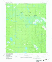
1956 Map of Black River B-6
USGS Topo · Published 1983About this map
Yukon Flats dominate this landscape in the mid-1950s, revealing a complex aquatic network within the Yukon Flats National Wildlife Refuge. The map captures the meandering paths of the Little Black River and Grass River, alongside smaller waterways like Sucker River and Big Creek. This terrain is defined by its numerous standing water bodies, including Tiechovun Lake, Mardow Lake, and the Vunle Lakes cluster. Human presence is sparse in this subarctic wilderness, marked primarily by a lone Tractor Trail cutting through the northwestern section. This 1956 survey provides a record of the region's hydrology and land management boundaries before the significant legislative changes of the 1980s, offering a clear view of the natural drainage patterns of this vast interior Alaskan basin.
Find a feature on this map
11 named features on this map. Tap any name to fly to it.
Don’t see what you’re looking for? This feature index may not catch every label — zoom into the map to look around manually.
Map Details
Editions of this 1956 Black River B-6 Map
3 editions found
Other maps of this area

1951 · Fort Yukon
USGS Topo · 1:250,000

1951 · Black River
USGS Topo · 1:250,000

1956 · Fort Yukon C-1
USGS Topo · 1:63,360

1956 · Black River B-6
USGS Topo · 1:63,360

1956 · Black River B-5
USGS Topo · 1:63,360

1956 · Black River C-6
USGS Topo · 1:63,360

1956 · Fort Yukon B-1
USGS Topo · 1:63,360

1956 · Black River C-5
USGS Topo · 1:63,360

1956 · Fort Yukon A-1
USGS Topo · 1:63,360

1956 · Black River A-6
USGS Topo · 1:63,360