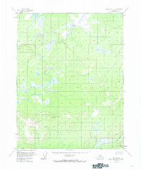
1956 Map of Black River D-3
USGS Topo · Published 1973About this map
Negrohead Mountain dominates the southern landscape of this interior Alaskan wilderness, rising above a complex network of wetlands and subarctic watercourses. Surveyed in the mid-1950s, the terrain is defined by its drainage patterns, with Rat Creek winding through the northern reaches while Kevinjik Creek and David Creek carve through the varied elevations of the east and south. This document illustrates a remote region of the Yukon-Koyukuk area before significant modern modification, where the Bureau of Land Management identified vast tracts of unsurveyed and unmarked lands. The intricate depiction of marshes and small lakes highlights the hydrological character of the Black River basin, providing a record of the natural topography as it existed in the mid-20th century.
Find a feature on this map
4 named features on this map. Tap any name to fly to it.
Don’t see what you’re looking for? This feature index may not catch every label — zoom into the map to look around manually.
Map Details
Editions of this 1956 Black River D-3 Map
2 editions found
Other maps of this area

1951 · Black River
USGS Topo · 1:250,000

1951 · Coleen
USGS Topo · 1:250,000

1956 · Coleen
USGS Topo · 1:250,000

1956 · Black River D-3
USGS Topo · 1:63,360

1956 · Black River D-4
USGS Topo · 1:63,360

1956 · Coleen A-3
USGS Topo · 1:63,360

1956 · Black River C-2
USGS Topo · 1:63,360

1956 · Black River D-2
USGS Topo · 1:63,360

1956 · Black River C-4
USGS Topo · 1:63,360

1956 · Coleen A-4
USGS Topo · 1:63,360