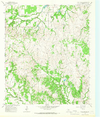
1965 Map of Bluff Dale
USGS Topo · Published 1967About this map
The North Paluxy River winds through the southwestern corner of this Erath County landscape, defining a terrain dominated by deeply incised creek valleys and limestone ridges. In the mid-1960s, this area remained largely rural, characterized by scattered ranching operations and family landmarks such as the Houston Ranch and Bishop Cem near the northern boundary. The intricate drainage network is a central feature of the map, with Kickapoo Creek and Berrys Creek cutting through the central hills, while Wolf Creek and its East Branch drain the eastern slopes. Small-scale industrial activity is evidenced by several Gravel Pits located near the waterways, and a prominent Pipeline cuts across the southern portion of the quadrangle. The map also records the Erath Co Hood Co line, marking the jurisdictional divide in an area otherwise defined by its rugged watercourses like Baileys Lake and Mule Creek.
Find a feature on this map
17 named features on this map. Tap any name to fly to it.
Don’t see what you’re looking for? This feature index may not catch every label — zoom into the map to look around manually.
Map Details
Editions of this 1965 Bluff Dale Map
Other maps of this area

1889 · Granbury
USGS Topo · 1:125,000

1890 · Stephenville
USGS Topo · 1:125,000

1920 · Stephenville
USGS Topo · 1:125,000

1931 · Tolar
USGS Topo · 1:62,500

1954 · Dallas
USGS Topo · 1:250,000

1954 · Abilene
USGS Topo · 1:250,000

1958 · Dallas
USGS Topo · 1:250,000

1958 · Abilene
USGS Topo · 1:250,000
1960 · Tolar
USGS Topo · 1:24,000

1961 · Johnsville
USGS Topo · 1:24,000