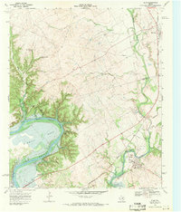
1968 Map of Blum
USGS Topo · Published 1971About this map
The Brazos River carves a dramatic oxbow at Kimball Bend, a central geographical feature of this late 1960s survey where the borders of Johnson, Hill, and Bosque counties converge. This era of the landscape is defined by the significant footprint of Lake Whitney, which has altered the traditional river drainage of Nolan River and Ham Creek. A notable historical layer is preserved through the marking of the Chisholm Trail, which cuts across the terrain south of the river, providing a spatial link to the cattle-driving history of the region.
Find a feature on this map
35 named features on this map. Tap any name to fly to it.
Don’t see what you’re looking for? This feature index may not catch every label — zoom into the map to look around manually.
Map Details
Editions of this 1968 Blum Map
2 editions found
Other maps of this area

1889 · Granbury
USGS Topo · 1:125,000

1891 · Cleburne
USGS Topo · 1:125,000

1894 · Cleburne
USGS Topo · 1:125,000

1924 · Cleburne 3-B
USGS Topo · 1:48,000

1924 · Cleburne 3-C
USGS Topo · 1:48,000

1924 · Granbury 4-a
USGS Topo · 1:48,000

1927 · Blum
USGS Topo · 1:62,500

1928 · Godley
USGS Topo · 1:62,500

1931 · Morgan
USGS Topo · 1:62,500

1954 · Dallas
USGS Topo · 1:250,000