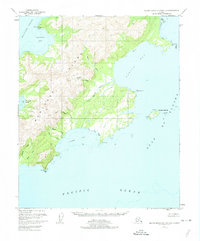
1951 Map of Blying Sound D-1 and D-2
USGS Topo · Published 1974About this map
Montague Island dominates this 1951 topographic study, situated where the Gulf of Alaska meets the Pacific Ocean. This coastal landscape is entirely contained within the Chugach National Forest, characterized by a complex network of waterways including the Patton River and Nellie Martin River which drain into the broad Patton Bay. Evidence of human activity is sparse, marked primarily by a solitary Cabin on the northern coast near Pt Bazil and Hanning Bay.
Find a feature on this map
26 named features on this map. Tap any name to fly to it.
Don’t see what you’re looking for? This feature index may not catch every label — zoom into the map to look around manually.
Map Details
Editions of this 1951 Blying Sound D-1 and D-2 Map
4 editions found
Other maps of this area

1946 · Blying Sound
USGS Topo · 1:250,000

1951 · Blying Sound
USGS Topo · 1:250,000

1951 · Seward
USGS Topo · 1:250,000

1951 · Seward A-2
USGS Topo · 1:63,360

1951 · Seward A-3
USGS Topo · 1:63,360

1951 · Blying Sound D-1 and D-2
USGS Topo · 1:63,360

1951 · Seward A-1
USGS Topo · 1:63,360

1952 · Seward A-3
USGS Topo · 1:63,360

1953 · Seward A-2
USGS Topo · 1:63,360

1953 · Seward A-1
USGS Topo · 1:63,360