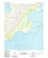
1951 Map of Blying Sound D-1 and D-2
USGS Topo · Published 1988About this map
Montague Island's southern coastline faces the Pacific Ocean and the Gulf of Alaska in this survey based on mid-century aerial photography. The map depicts a wilderness landscape of coastal inlets and mountainous terrain, where human presence is marked only by isolated Cabins near the shoreline. Significant drainage systems such as the Patton River and Nellie Martin River feed into the expansive Patton Bay, while the western edge is defined by the Montague Strait. The topography is detailed with coastal landmarks like Cape Cleare and Point Bazil, alongside the offshore Wooded Islands. This document preserves the late-period frontier character of the region before modern changes, illustrating the intricate network of glacial streams including Tortuous Creek and Deception Creek that carve through the Chugach National Forest.
Find a feature on this map
36 named features on this map. Tap any name to fly to it.
Don’t see what you’re looking for? This feature index may not catch every label — zoom into the map to look around manually.
Map Details
Editions of this 1951 Blying Sound D-1 and D-2 Map
4 editions found
Other maps of this area

1946 · Blying Sound
USGS Topo · 1:250,000

1951 · Blying Sound
USGS Topo · 1:250,000

1951 · Seward
USGS Topo · 1:250,000

1951 · Seward A-2
USGS Topo · 1:63,360

1951 · Seward A-3
USGS Topo · 1:63,360

1951 · Blying Sound D-1 and D-2
USGS Topo · 1:63,360

1951 · Seward A-1
USGS Topo · 1:63,360

1952 · Seward A-3
USGS Topo · 1:63,360

1953 · Seward A-2
USGS Topo · 1:63,360

1953 · Seward A-1
USGS Topo · 1:63,360