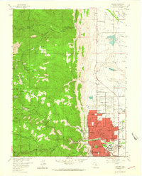
1957 Map of Boulder
USGS Topo · Published 1964About this map
Boulder and its rugged western foothills are captured in this mid-century survey, revealing a landscape defined by the transition from urban growth to steep mining country. The eastern portion shows the city's expanding residential grid, anchored by the University of Colorado and numerous neighborhood institutions like Whittier Sch and the Mt St Gertrude Academy. Beyond the city limits, the terrain rises sharply into the Roosevelt National Forest, where a dense network of canyons—including Lefthand Canyon, Sunshine Canyon, and Boulder Canyon—serves as the backdrop for a legacy of hard-rock mining. Dozens of specific shafts such as the Little Bonnie Mine, Sun and Moon Mine, and Yellow Pine Mine are precisely plotted, marking the historic extraction efforts that once populated small mountain settlements like Sunshine and Crisman. The intricate system of water management is also visible, with Farmers Ditch and the Silver Lake Ditch threading through the foothills to the valley floor.
Find a feature on this map
86 named features on this map. Tap any name to fly to it.
Don’t see what you’re looking for? This feature index may not catch every label — zoom into the map to look around manually.
Map Details
Editions of this 1957 Boulder Map
3 editions found
Other maps of this area

1899 · West Denver
USGS Topo · 1:125,000

1902 · Boulder
USGS Topo · 1:62,500

1904 · Niwot
USGS Topo · 1:62,500

1904 · Boulder
USGS Topo · 1:62,500

1906 · Blackhawk
USGS Topo · 1:62,500

1942 · Eldorado Springs
USGS Topo · 1:24,000

1942 · Louisville
USGS Topo · 1:31,680

1942 · Tungsten
USGS Topo · 1:24,000

1944 · Eldorado Springs
USGS Topo · 1:31,680
1944 · Tungsten
USGS Topo · 1:31,680