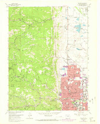
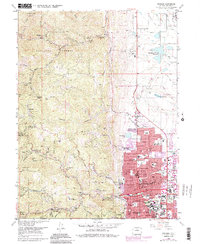
1966 Map of Boulder
USGS Topo · Published 1973About this map
The University of Colorado and the growing urban grid of Boulder dominate the eastern plains, while the western half of the map rises into the foothills of the Roosevelt National Forest. This 1960s survey shows the city's upward expansion, with purple revision tints marking new residential developments near Wonderland Lake and the Foothills Highway. Along the mountain front, the map documents a legacy of extraction, locating the Golden Age Mine near Springdale and the Poorman Mine in the steep terrain above Sunshine Canyon. The transition from the established city streets, marked by numerous schools like Whittier Sch and Mapleton Sch, to the more isolated mountain settlements like Sunshine and Salina, illustrates the geography of the Front Range before more modern suburban infill. Cultural landmarks range from the scientific Radio Telescopes to the Mountain View Cemetery and the Drive-in Theater on the city's north edge.
Find a feature on this map
67 named features on this map. Tap any name to fly to it.
Don’t see what you’re looking for? This feature index may not catch every label — zoom into the map to look around manually.
Map Details
Editions of this 1966 Boulder Map
5 editions found
Other maps of this area

1899 · West Denver
USGS Topo · 1:125,000

1902 · Boulder
USGS Topo · 1:62,500

1904 · Niwot
USGS Topo · 1:62,500

1904 · Boulder
USGS Topo · 1:62,500

1906 · Blackhawk
USGS Topo · 1:62,500

1942 · Eldorado Springs
USGS Topo · 1:24,000

1942 · Louisville
USGS Topo · 1:31,680

1942 · Tungsten
USGS Topo · 1:24,000

1944 · Eldorado Springs
USGS Topo · 1:31,680
1944 · Tungsten
USGS Topo · 1:31,680