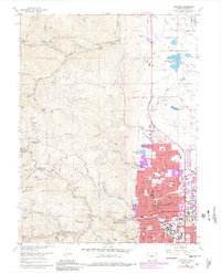
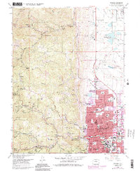
1966 Map of Boulder
USGS Topo · Published 1980About this map
Boulder and the surrounding Front Range foothills are shown at a point of significant transition, with purple-tinted revisions from 1978 highlighting the rapid expansion of the city's urban footprint. The street grid is densely detailed from Baseline Road north toward Linden Ave, anchored by the expansive campus of the University of Colorado. To the west, the rugged topography is dotted with historical mining sites like the Poorman Mine and Red Sign Mine, along with numerous small settlements such as Jamestown and Salina that trace the path of Fourmile Creek and Left Hand Creek. The map documents a blend of academic, industrial, and recreational land use, featuring the Boulder Mountain Park and the specialized scientific infrastructure of the Radio Telescopes near Mesa Reservoir.
Find a feature on this map
67 named features on this map. Tap any name to fly to it.
Don’t see what you’re looking for? This feature index may not catch every label — zoom into the map to look around manually.
Map Details
Editions of this 1966 Boulder Map
5 editions found
Other maps of this area

1899 · West Denver
USGS Topo · 1:125,000

1902 · Boulder
USGS Topo · 1:62,500

1904 · Niwot
USGS Topo · 1:62,500

1904 · Boulder
USGS Topo · 1:62,500

1906 · Blackhawk
USGS Topo · 1:62,500

1942 · Eldorado Springs
USGS Topo · 1:24,000

1942 · Louisville
USGS Topo · 1:31,680

1942 · Tungsten
USGS Topo · 1:24,000

1944 · Eldorado Springs
USGS Topo · 1:31,680
1944 · Tungsten
USGS Topo · 1:31,680