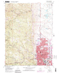
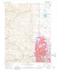
1966 Map of Boulder
USGS Topo · Published 1985About this map
Boulder and its rugged foothills are captured during a period of significant expansion, where urban development meets long-standing mining and forest boundaries. The city core is dense with institutional landmarks, dominated by the University of Colorado and numerous neighborhood schools like Mapleton Sch and Highland Sch. To the west, the landscape rises sharply into the Roosevelt National Forest, where a legacy of hard-rock mining is evident at the Golden Age Mine and Poorman Mine. The map traces the essential water infrastructure of the era, from the Boulder Filtration Plant to the Silver Lake Ditch, reflecting the engineering required to support a growing mountain community. Small settlements and former mining camps like Salina, Crisman, and Springdale remain distinct along the winding canyon roads, providing a clear look at the historic settlement patterns of the Front Range.
Find a feature on this map
70 named features on this map. Tap any name to fly to it.
Don’t see what you’re looking for? This feature index may not catch every label — zoom into the map to look around manually.
Map Details
Editions of this 1966 Boulder Map
5 editions found
Other maps of this area

1899 · West Denver
USGS Topo · 1:125,000

1902 · Boulder
USGS Topo · 1:62,500

1904 · Niwot
USGS Topo · 1:62,500

1904 · Boulder
USGS Topo · 1:62,500

1906 · Blackhawk
USGS Topo · 1:62,500

1942 · Eldorado Springs
USGS Topo · 1:24,000

1942 · Louisville
USGS Topo · 1:31,680

1942 · Tungsten
USGS Topo · 1:24,000

1944 · Eldorado Springs
USGS Topo · 1:31,680
1944 · Tungsten
USGS Topo · 1:31,680