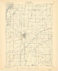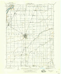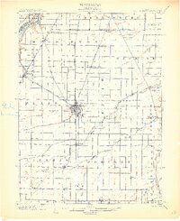
1903 Map of Bowling Green
USGS Topo · Published 1903About this map
Bowling Green serves as the central hub of this Wood County landscape, where the grid-like survey lines of Northwest Ohio intersect a complex network of turn-of-the-century transportation. The Maumee River defines the northwestern corner near Waterville, accompanied by the Miami and Erie Canal, a remnant of an earlier era of waterborne transit. The map reveals the intense competition between rail lines, showing the Cincinnati Hamilton and Dayton Railroad and the Toledo and Ohio Central Railroad alongside newer developments like the Columbus Fremont and Bowling Green Electric Line. Numerous small rural nodes like Hull Prairie, Sugar Ridge, and Six Points illustrate the high density of small-town settlement in the Black Swamp region before the automobile centralized commerce. The drainage pattern, featuring the North Branch Portage River and Middle Branch Portage River, highlights the extensive engineering required to reclaim this productive farmland.
Find a feature on this map
56 named features on this map. Tap any name to fly to it.
Don’t see what you’re looking for? This feature index may not catch every label — zoom into the map to look around manually.
Map Details
Editions of this 1903 Bowling Green Map
3 editions found