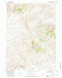
1953 Map of Bradley Peak
USGS Topo · Published 1975About this map
Bradley Peak dominates this high-altitude landscape in Carbon County, where the Ferris Mountains and Seminoe Mountains meet. The 1953 field check captures a transitional era for local land use, documenting the Elkhorn Stage Station (Ruins) and several inactive ranch sites including R S Ranch (Aband) and Boot Ranch (Aband). Evidence of regional resource extraction is visible through the Sunday Morning Mine (Active) and a Coal Mine located near Suttle Creek. The complex hydrology of the area is mapped through an extensive network of drainage basins like Pattison Basin and irrigation efforts marked as Ditch, while natural features such as Sand Dunes and Mahoney Lake highlight the diverse terrain. This survey provides a precise record of the remote ranching and mining infrastructure that once supported the settlement of this mountainous Wyoming interior.
Find a feature on this map
39 named features on this map. Tap any name to fly to it.
Don’t see what you’re looking for? This feature index may not catch every label — zoom into the map to look around manually.
Map Details
Editions of this 1953 Bradley Peak Map
4 editions found
Other maps of this area

1953 · Bradley Peak
USGS Topo · 1:24,000

1953 · Seminoe Dam
USGS Topo · 1:24,000

1953 · Wild Horse Mountain
USGS Topo · 1:24,000

1953 · Seminoe Dam SW
USGS Topo · 1:24,000

1953 · Ferris
USGS Topo · 1:24,000

1953 · Pathfinder Reservoir SW
USGS Topo · 1:24,000

1953 · Buzzard Ranch
USGS Topo · 1:24,000

1953 · Spanish Mine
USGS Topo · 1:24,000

1953 · Riddle Cut
USGS Topo · 1:24,000

1955 · Casper
USGS Topo · 1:250,000