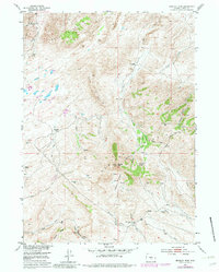
1953 Map of Bradley Peak
USGS Topo · Published 1982About this map
The Ferris Mountains and Seminoe Mountains converge in this high-desert landscape of Carbon County, where mid-century ranching and mining infrastructure was already transitioning into ruins and abandoned sites. Evidence of the early frontier remains at the Elkhorn Stage Station, while several resource operations appear inactive, including the Sunday Morning Mine, Penn Mine, and a Coal Mine. The terrain is characterized by dramatic elevation changes, with Bradley Peak rising as a central landmark above Pattison Basin Creek. Water sources are critical in this arid environment, marked by the presence of Sand Springs, Mahoney Lake, and numerous seasonal drainages like Deweese Creek and Junk Creek. The map also captures the remains of homesteading history through the R S Ranch and Root Ranch, alongside the modern industrial footprint of a Pipe Line traversing the northwestern corner.
Find a feature on this map
42 named features on this map. Tap any name to fly to it.
Don’t see what you’re looking for? This feature index may not catch every label — zoom into the map to look around manually.
Map Details
Editions of this 1953 Bradley Peak Map
4 editions found
Other maps of this area

1953 · Bradley Peak
USGS Topo · 1:24,000

1953 · Seminoe Dam
USGS Topo · 1:24,000

1953 · Wild Horse Mountain
USGS Topo · 1:24,000

1953 · Seminoe Dam SW
USGS Topo · 1:24,000

1953 · Ferris
USGS Topo · 1:24,000

1953 · Pathfinder Reservoir SW
USGS Topo · 1:24,000

1953 · Buzzard Ranch
USGS Topo · 1:24,000

1953 · Spanish Mine
USGS Topo · 1:24,000

1953 · Riddle Cut
USGS Topo · 1:24,000

1955 · Casper
USGS Topo · 1:250,000