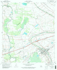
1970 Map of Breaux Bridge
USGS Topo · Published 1986About this map
Breaux Bridge and the winding Bayou Teche anchor this 1970 landscape, where the agricultural traditions of St. Martin Parish meet modern industrial expansion. The map details a complex hydraulic network including the Vermilion River, Lake Grande Marie, and numerous coulees like Coulee Cocodrie that drain this low-lying territory. The intersection of the Southern Pacific and Missouri Pacific railroads highlights the area's role as a transportation hub, while the emergence of the Anse La Butte Oil and Gas Field indicates the transition from a purely agrarian economy to one supported by natural resources.
Find a feature on this map
37 named features on this map. Tap any name to fly to it.
Don’t see what you’re looking for? This feature index may not catch every label — zoom into the map to look around manually.
Map Details
Editions of this 1970 Breaux Bridge Map
3 editions found
Other maps of this area

1939 · St. Martinsville
USGS Topo · 1:62,500

1940 · Arnaudville
USGS Topo · 1:62,500

1946 · Lafayette
USGS Topo · 1:31,680

1952 · Lake Charles
USGS Topo · 1:250,000

1954 · Lafayette
USGS Topo · 1:31,680

1954 · Lake Charles
USGS Topo · 1:250,000

1954 · Baton Rouge
USGS Topo · 1:250,000

1955 · Lafayette
USGS Topo · 1:24,000
1955 · Lafayette
USGS Topo · 1:62,500

1956 · Baton Rouge
USGS Topo · 1:250,000