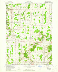
1960 Map of Brighton
USGS Topo · Published 1961About this map
The Vermilion River and East Branch Black River carve through the agricultural landscape of south-central Lorain County, defining the drainage patterns that shaped local development. During the early 1960s, small crossroads communities such as Brighton and Rochester remained vital local hubs, connected by a network of rural routes like Peck Wadsworth Road and Butler Road. The map reveals a high-density rail infrastructure essential for the era's commerce, with the New York Chicago and St Louis and the New York Central lines cutting west across the townships. These railroads intersect with older, established settlements and smaller locales like White Fox and Zenobia, providing a clear view of the mid-century intersection between rural farming life and industrial transportation. The terrain is relatively level with gentle depressions near the waterways, such as Charlemont Creek, reflecting the glacial history of the region.
Find a feature on this map
39 named features on this map. Tap any name to fly to it.
Don’t see what you’re looking for? This feature index may not catch every label — zoom into the map to look around manually.
Map Details
Editions of this 1960 Brighton Map
3 editions found
Other maps of this area

1901 · Oberlin
USGS Topo · 1:62,500

1903 · Vermilion
USGS Topo · 1:62,500

1903 · Oberlin
USGS Topo · 1:62,500

1904 · Wellington
USGS Topo · 1:62,500

1906 · Wellington
USGS Topo · 1:62,500

1908 · New London
USGS Topo · 1:62,500

1956 · Toledo
USGS Topo · 1:250,000

1959 · Berlin Heights
USGS Topo · 1:24,000

1959 · Kipton
USGS Topo · 1:24,000

1960 · Oberlin
USGS Topo · 1:24,000