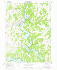
1961 Map of Brinkhaven
USGS Topo · Published 1978About this map
The confluence of the Mohican River and Jelloway Creek anchors this landscape in eastern Knox County, where the village of Brinkhaven (Gann) sits at a historic crossroads. By the mid-20th century, the local economy is clearly defined by an extensive Oil Field and numerous active gas wells that punctuate the terrain from Tager Valley to the heights of Turkey Ridge. Evidence of the region's transportation history is visible in the Pennsylvania line and the Old Railroad Grade winding through the river valley toward Cavallo.
Find a feature on this map
41 named features on this map. Tap any name to fly to it.
Don’t see what you’re looking for? This feature index may not catch every label — zoom into the map to look around manually.
Map Details
Editions of this 1961 Brinkhaven Map
4 editions found
Other maps of this area

1912 · Loudonville
USGS Topo · 1:62,500

1912 · Gambier
USGS Topo · 1:62,500

1912 · Perrysville
USGS Topo · 1:62,500

1913 · Brinkhaven
USGS Topo · 1:62,500

1914 · Gambier
USGS Topo · 1:62,500

1914 · Loudonville
USGS Topo · 1:62,500

1915 · Brinkhaven
USGS Topo · 1:62,500

1915 · Perrysville
USGS Topo · 1:62,500

1943 · Gambier
USGS Topo · 1:62,500

1943 · Loudonville
USGS Topo · 1:62,500