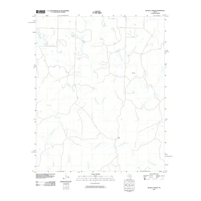
2010 Map of Buckle L Ranch
USGS Topo · Published 2010About this map
The Buckle L Ranch serves as a primary landmark in this ranching landscape of Cottle County, where the southern portion of the map is defined by the braided channels of the North Pease River. The terrain is characterized by a series of north-to-south drainage systems that carve through the plains, including Scatterbranch Creek, Chimney Creek, and the uniquely named Big Nasty Creek and Little Nasty Creek. Rising above the surrounding draws is the prominent landform of Flat Top, which sits just north of the headwaters of Flat Top Creek. This 2010 survey reflects a contemporary view of North Texas cattle country, where a network of county roads like Co RD 12 and Co RD BB provide the only access across the wide, water-cut expanses.
Find a feature on this map
19 named features on this map. Tap any name to fly to it.
Don’t see what you’re looking for? This feature index may not catch every label — zoom into the map to look around manually.
Map Details
Editions of this 2010 Buckle L Ranch Map
This is the sole edition of this map. No revisions or reprints were ever made.
Other maps of this area

1954 · Plainview
USGS Topo · 1:250,000

1958 · Plainview
USGS Topo · 1:250,000

1967 · Buckle L Ranch
USGS Topo · 1:24,000

1967 · Hell Roaring Creek
USGS Topo · 1:24,000

1967 · Kirkland South
USGS Topo · 1:24,000

1967 · Kirkland North
USGS Topo · 1:24,000

1967 · Dunlap
USGS Topo · 1:24,000
1967 · Baker
USGS Topo · 1:24,000

1967 · Childress
USGS Topo · 1:24,000

1967 · Carey
USGS Topo · 1:24,000