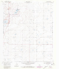
1968 Map of Bula
USGS Topo · Published 1981About this map
Muleshoe National Wildlife Refuge occupies the northwestern corner of this High Plains landscape, protecting a chain of alkaline depressions including Upper Pauls Lake, Lower Pauls Lake, and Lower Goose Lake. These saline lakes, typical of the Llano Estacado, provide a stark contrast to the surrounding agricultural grid. The small settlement of Bula sits near the eastern edge, marked by a few structures and a Wt near the highway, serving as a focal point for the local ranching and farming community.
Find a feature on this map
12 named features on this map. Tap any name to fly to it.
Don’t see what you’re looking for? This feature index may not catch every label — zoom into the map to look around manually.
Map Details
Editions of this 1968 Bula Map
3 editions found
Other maps of this area

1954 · Clovis
USGS Topo · 1:250,000

1954 · Brownfield
USGS Topo · 1:250,000

1958 · Brownfield
USGS Topo · 1:250,000

1958 · Clovis
USGS Topo · 1:250,000

1962 · Brownfield
USGS Topo · 1:250,000

1962 · Needmore
USGS Topo · 1:24,000

1962 · Baileyboro
USGS Topo · 1:24,000

1962 · Sudan
USGS Topo · 1:24,000

1964 · Pep
USGS Topo · 1:24,000
1964 · Beck
USGS Topo · 1:24,000