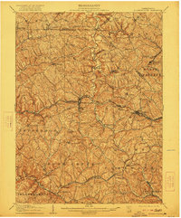
1906 Map of Burgettstown
USGS Topo · Published 1922About this map
Burgettstown serves as a central hub in this early twentieth-century survey of Washington County and its borderlands. The landscape is defined by the convergence of heavy industry and rural settlement, particularly visible in the rail corridors of the Pittsburgh Cincinnati Chicago and St Louis RR and the Wabash Terminal RR. The extraction economy of the era is anchored by sites like the Francis Mine near Dinsmore and the Shaw Mine to the east. Smaller communities and family-named locales like Pattersons Mill, Bavington, and North Star Tyre P O are scattered across a complex network of runs and forks, including Cross Creek and Raccoon Creek. Notable landmarks such as the McDonald Waterworks and high points like Bald Knob provide orientation for those tracing the industrial and genealogical history of the Pennsylvania coal and steel belt.
Find a feature on this map
66 named features on this map. Tap any name to fly to it.
Don’t see what you’re looking for? This feature index may not catch every label — zoom into the map to look around manually.
Map Details
Editions of this 1906 Burgettstown Map
5 editions found
Other maps of this area

1901 · Amity
USGS Topo · 1:62,500

1901 · Beaver
USGS Topo · 1:62,500

1902 · Wheeling
USGS Topo · 1:62,500

1904 · Amity
USGS Topo · 1:62,500

1904 · Wellsville
USGS Topo · 1:62,500

1904 · Steubenville
USGS Topo · 1:62,500

1904 · Beaver
USGS Topo · 1:62,500

1904 · Carnegie
USGS Topo · 1:62,500

1904 · Burgettstown
USGS Topo · 1:62,500

1906 · Burgettstown
USGS Topo · 1:62,500
Featured Places
- Cecil Township, PA
- Independence Township, PA
- Robinson Township, PA
- Cross Creek Township, PA
- Independence Township, PA