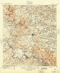
1909 Map of Burnet
USGS Topo · Published 1949About this map
The Colorado River and its confluence with the Llano River anchor this central Texas landscape at the opening of the twentieth century. The river system is a lifeline for the region, marked by numerous river crossings such as Tanyard Crossing, Wolf Crossing, and Nigger Crossing that predated modern bridge infrastructure. Along the rugged Backbone Ridge, industrial activity is evident at the Stone Quarry and the prominent Granite Mountain near Marble Falls.
Find a feature on this map
179 named features on this map. Tap any name to fly to it.
Don’t see what you’re looking for? This feature index may not catch every label — zoom into the map to look around manually.
Map Details
Editions of this 1909 Burnet Map
3 editions found

Other maps of this area

1885 · San Saba
USGS Topo · 1:125,000

1887 · Llano
USGS Topo · 1:125,000

1887 · Lampasas
USGS Topo · 1:125,000

1887 · Blanco
USGS Topo · 1:125,000

1887 · Burnet
USGS Topo · 1:125,000

1893 · Georgetown
USGS Topo · 1:125,000

1893 · Burnet
USGS Topo · 1:125,000

1894 · Fredericksburg
USGS Topo · 1:125,000

1894 · Lampasas
USGS Topo · 1:125,000

1894 · Gatesville
USGS Topo · 1:125,000